


I continue to muse over my brief visit to Maine's Acadia National Park. By the way, the misspelling contained in my Latin title is intentional. Arcadia (note the "r") is a large, somewhat wild region in the center of Greece's Peloponnese. But in Greek mythology, the term was understood to be what Wikipedia describes as "a poetic byword for an idyllic vision of unspoiled wilderness."
In the sixteenth century, an early explorer -- with the Greek myth in mind -- gave the name "Arcadia" to Maryland and Virginia, because of the forested beauty he beheld. With time, the word lost its "r," and the area it represented migrated northward step by step. Geographically, it ultimately referred to a French colony that occupied what is now the Canadian Maritime provinces, as well as northern Maine -- including the area of today's Acadia National Park. Parenthetically, the Louisiana "Cajuns" were French Acadians who fled British rule.
And so the morose warning displayed on a tombstone in Poussin's painting, "Et in Arcadia ego" ("I (Death) am even in Arcadia") becomes for my purposes the cheerful "Et in Acadia ego" ("I (your friendly blogger) am even in Acadia National Park").
But I amuse myself at my readers' expense.
Acadia National Park has a number of units, each separated from the others, but the most touristed portion is that on the eastern "lobe" of Mount Desert Island. (The island, a bit like Orcas Island in Washington, has two lobes, separated by Somes Sound.) The park occupies most of that eastern "lobe," excepting Bar Harbor in the northeast, and an area along the southern coast. Two peaks dominate the eastern lobe of the island: Cadillac Mountain (1,530 ft.) and Pemetic Mountain (1,248 ft.) To the west of these two peaks are two large lakes: Eagle Lake and Jordan Pond. And to the west of the lakes are a number of peaks, the highest being Sargent Mountain (1,373 ft.).
The park is a maze of trails and "carriage roads," but visitors who stay in their cars tend to limit themselves to the loop highway. The loop begins near Bar Harbor, heads south to Sand Beach, and then closely follows the coastline south, around Otter Point, and north, passing between the two lakes to the west and Cadillac and Pemetic Mountains to the east. There is also a spur road from the loop to the summit of Cadillac Mountain, which now requires a permit for vehicular access that must be obtained in advance.
The "carriage ways" are a unique feature of the park. They were built by John D. Rockefeller for the exclusive use of non-motorized travel -- especially horse-drawn carriages. They remain today a maze of spacious roads, open for use solely by pedestrians, bicycles, and horses. They are an easy way to see much of the park on foot or bike.
During my first visit in 2008, I climbed Pemetic Mountain. I left my rental car at Bubble Pond, and climbed to the summit. I note in my journal that,
The climb was steep and the trail was all rock and tree roots. It would have been impossible to discern the trail but for painted blue blazes and occasional cairns.
From the summit, I walked another 1.3 miles across a saddle to the lower summit of The Triad (698 ft.). From The Triad, I walked down 0.4 miles to a nearby carriage road, and walked another three miles back to my car. I recall the entire climb and hike as being a high point of my visit to the park.
For various reasons, I was unable to do this hike, or anything equally ambitious, this visit. Nor was I able to once more drive to the summit of Cadillac Mountain. I had obtained the necessary advance permit, but the permit was in my baggage that -- as noted in my prior post -- hadn't yet arrived. In any event, when I next visit Acadia, I think it would be much more worthwhile to climb Cadillac Mountain on foot -- hardly a Himalayan feat -- rather than drive up the road.
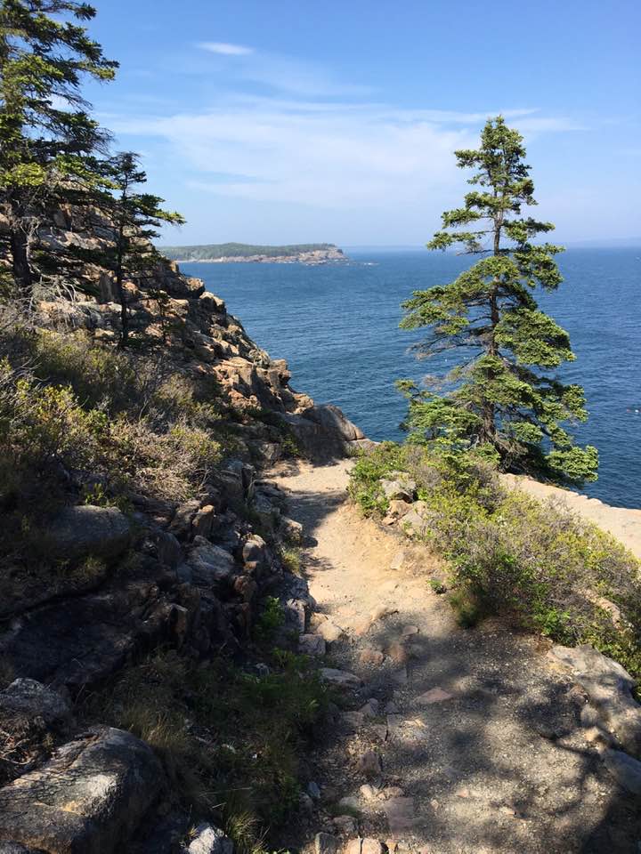
What I did have time for was a half hour or so poking around Sand Beach, and a significantly longer time following a cliff-top trail around Otter Point. The Otter Point trail is very enjoyable, often forested, and with magnificent views of the Atlantic, and of the cliffs dropping far below your feet.
When you see a map of the park, you note that the western "lobe" of Mount Desert Island is actually larger than that to the east. I tried exploring it in 2008, however, and wasn't that impressed. Most of the waterfront property is in private hands, and I was unable to get many ocean views. On the other hand, if you have time to leave the island, you should drive about fifty miles east to the section of the park on the Schoodic Peninsula. The loop road about the peninsula offers striking views, and gave me some of my best photographs in 2008.
In conclusion, it's clear that I was able to spend less time hiking and enjoying Acadia Park during last week's visit than I had in 2008. My primary problem was the time I had to spend trying to get information about the search for my baggage from United Airlines, and securing certain prescription medication that had been in my misplaced baggage. But beyond that problem, I simply allotted too little time for the actual park visit, relative to the time it took to fly to and from the east coast.
As I concluded in my prior post -- I hope to visit Bar Harbor and Acadia National Park again soon. And next time, I will plan on a much longer stay.
------------------------
Photo: On the cliff-top trail around Otter Point.
No comments:
Post a Comment